After passing over several brooks and traveling along vernal ponds teeming with life, the trail runs through an area with many glacial erratics. We had walked a little more than a mile when we were found ourselves facing a wide dirt road (Old Montauk Highway) that was once the only means of access to the Lighthouse. Continuing on the Paumanok Path we turned left, and then made a right quick onto a paved road. This paved road leads to the Atlantic bluffs and a magnificent overlook where we stopped for our picnic.
After drinking in the breathtaking view and enjoying our snacks, John and I discussed some options. Coincidently, we had each already decided to walk the Money Pond Trail. I had planned to walk back with the group and then continue north on the Seal Haulout Trail to North Road, which would take me to the Money Pond Trail. John convinced me instead to continue to walk on Old Montauk Highway, loop around the Lighthouse, and pick up the Money Pond Trail from the highway loop road.
We made sure to tell our hike leader that we were striking out on our own, and then John and I continued on the Paumanok Path towards Montauk Point. When we reached Turtle Cove, John pointed out that if you didn’t know that the Paumanok Path continues around the Lighthouse you wouldn’t notice the faded white blazes on the rocks.
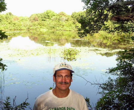
After an exhilarating walk on the rocks, we visited the concession stand, refilled our water bottles, and used the facilities. We walked out the front of the building, turned right and walked the road for a short distance. On the right side of the road we found the green sign and blazes of the Money Pond Trail. John noted the extraordinary size of some of the shadbush. I in turn was struck by how expertly the trail was designed to run along the naturally occurring ridges. These ridges were formed by deposits of wind-blown sand that were later stabilized by vegetation. After traveling about a mile over rolling terrain we came upon Money Pond. John took a picture of me with the pond in the background. Legend has it that Captain Kidd buried some of his treasure here, hence the name. John and I continued west to the Seal Haulout Trail. New York State Parks has done a great job of blazing these trails. We saw the Seal Haulout Trail sign and yellow blazes and headed south towards Montauk Highway then took a short stretch of the Point Woods Trail back to our cars on Camp Hero Road.
To plan our hike John and I referred to the Montauk Point Trail Guide by Charles Whalen. Another excellent resource for exploring this area and the lands adjacent to it is Charles Whalen’s East Hampton Trail Guide.
I am also indebted to Mike Bottini for the information I have garnered from his book The Trail Guide to the South Fork where he describes these trails in great detail.
Directions: Take Montauk Highway east through Montauk Village. Camp Hero Road in Montauk is 1.5 miles east of the entrance to T. Roosevelt County Park. It is the first right past the Oyster Pond overlook. The trail begins on the right side of Camp Hero Road, 100 yards south of the intersection with the Highway. Park on the shoulder of the road. State Parks placed a Point Woods trail sign here and blazed the short distance to the Paumanok Path.
|