|
|
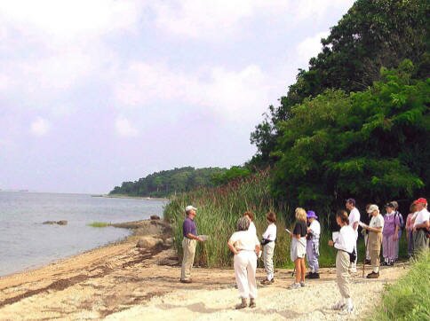
Last summer I joined the East Hampton Trails Preservation Society (EHTPS) on Lee Dion’s hike “East Hampton’s Ghost Town,” a 3-mile tour through an abandoned Northwest settlement. While leading the hike through the Grace Estate Preserve in the Northwest Woods, Lee enabled us to visualize the once thriving colonial town. The walk takes you over a stream, by freshwater ponds, and along the Northwest Harbor Shoreline. We enjoyed lovely vistas of the Harbor while we listened to accounts of the colorful personalities who centuries ago resided in an area now all but reclaimed by nature. The colonial settlement was abandoned and W.R. Grace purchased the 626 acres in the early 1900’s, but never lived here. In 1985, the holders of his estate sold the land to a developer who began plans for a large summer community. These plans were scaled down to a 110-acre development and the Town of East Hampton purchased the remaining 516 acres by public referendum.
Lee, a former science teacher at East Hampton High School, freely shared his understanding of the natural features we visited. In the early 1980’s he was president of the newly formed East Hampton Trails Preservation Society.
|
The ease with which he speaks of pond, kettle hole, and colonial strife shows that he has led this hike many times. Your experience of this area will be greatly enriched if you walk it while referring to the informational pamphlet created by Lee. You can obtain the pamphlet at no charge by mailing a stamped, self-addressed envelope to EHTPS, , and ask for The Ghost Town Tour Pamphlet. Another excellent resource for exploring this area is Charles Whalen’s East Hampton Trail Guide.
Before you cross the Northwest Road to start your tour of the Ghost Town, you may be interested in visiting the plaque that commemorates an old schoolhouse. This monument is slightly above ground level by the south side of the parking area. Also, if you walk the trail back into the woods from the parking area you will find the Scoy cemetery with its ancient headstones. If you follow Lee’s Ghost Town Tour, the cemetery will be your last stop before returning to the parking area.
To begin the hike, cross the road to the monument dated 1985, dedicating the purchase of this property and declaring it parkland by public referendum. As you walk, note the painted white blazes along the trail; you are now walking along the Paumanok Path. This portion of the Path is a woods road used by hunters and enforcement personnel, so you may on rare occasions encounter a motor vehicle here. If you are following Lee’s pamphlet you will be looking for metal house numbers seven feet above the ground that are used to identify the “steps” in his interpretive hike. When I re-walked the hike I found that I missed several of the numbered steps, but I was still able to stay on the designated trails by paying close attention to Lee’s narrative. Where the Paumanok Path turns left, continue straight. This will put you on Scoys Pond Road. Continue until you are looking out onto the Harbor, and then retrace your steps to the first right turn. You are now walking parallel to the shoreline. After a short distance you will find the shore again to your right. This is a pretty place even though the shoreline has been churned up by recreational vehicles. At this point, turn around and continue straight up the trail. This is another woods road called Whalebone Landing Road. Take this woods road to Five Corners. The trail you want to take is at 10 o’clock; it is not straight ahead and it is not the white blazed Paumanok Path. When you cross back over Northwest Road two quick left turns will bring you past the old cemetery and back to your car.
Directions: On Montauk Highway heading east pass the Wainscott Town sign. Pass Daniels Hole Road, and take the next left turn onto Stephen Hands Path. Follow the signs for Cedar Point Park. Bear left onto Old Northwest Road. Stay on Old NW Rd. until you reach Northwest Road. Make a right onto Northwest Road. Park by the School House Plaque on Northwest Rd, about 3/10 mile from the intersection with Alewive Brook Rd.
|
