|
|
As a tribute to Ms. Gronlund, a native of Sag Harbor, Barcelona Neck was rededicated as the Linda Gronlund Memorial Nature Preserve. Linda Gronlund was aboard the flight that crashed in Pennsylvania during the 9-11 attacks. The preserve was dedicated by New York State DEC, owners of the property on Saturday, September 11, 2004.
I had last visited this peninsula in the Northwest Harbor several years ago, but when I returned this week I found that the awesome harbor view and huge beds of cinnamon fern nestled between upland forest and lowland swamps were just as I had remembered them. In order to avoid the golf traffic, I parked on the shoulder of Swamp Road (where it intersects with Edwards Hole Road and becomes East Side Road) instead of in the Sag Harbor Golf Club lot located within the preserve.
|
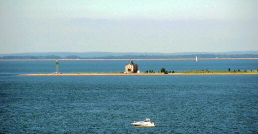
After walking a short distance north on East Side Road, you have a choice of either staying on the woods road or taking the road less traveled. I tried both. First I turned left where I saw a blue DEC disk on a tree. I started following these discs, but because many of them had popped off the trees, I lost the trail and walked several arcs through the woods until I found it again. I then found a large segment of trail that could be followed, but it took me into wetlands. My feet sank into the bog in some places; in other places I found planks to walk on. This southern section of the DEC Barcelona loop is rarely used; plants are closing in on the tread, but it is quite lovely and deserving of some attention. When this trail crossed over the golf club road I followed it for a while but saw no blue disc blazes. I needed to use dead reckoning to get around the outer edge of the golf course and end up on the West Side Road. I thought that my readers might not welcome such an excursion, so I walked back to where I made my turn and tried a different route. This time I turned to the right off East Side Road, and saw two white painted dots on a tree; then as I followed the path I noticed some blue disks marking the trail. This took me through enchanting white pinewoods by Northwest Creek. The trail looped away from the golf course and brought me out by the back of the clubhouse. Here I found another woods road to my right marked by a sign that read “Road Graded: Drive Slowly” and a DEC sign saying “Access by Permit Only”. I followed this road for quite a distance until I saw the blue DEC blazes again. I eventually came upon a spur trail leading to the right that took me to a place with a view of the Creek. Continuing on East Road, I made my way to the channel that opens into the harbor, then got back on the East Road only to come upon a “No Trespassing” sign. I turned around and headed back until I found a trail to my right marked by upright logs and a sign showing a no bikes symbol. I followed bike tracks to Third Road and then to the northern edge of the Neck where coastal winds blow sand up over the bluffs. When you come upon these “blow-outs” your first impression is that you are in a construction area, but if you climb up the mounds, you are rewarded with a breathtaking view of the Harbor from a height of 80 feet. The accompanying photograph was taken atop the blow-out. I used a telephoto lens so I could get a better view of the Cedar Point Lighthouse.
As you head back (on West Side Road), there are a number of left turns you can take to visit the lovely inner hardwood forests. If you continue along the shore on West Side Road, eventually you will find yourself walking through the golf course, past the back of the clubhouse and back towards Edwards Hole Road.
If you wish to walk on DEC property, you need a DEC Access Permit. For more information call . If you are caught without a permit, you could pay a fine as high as $250. The permits are free, and they are used as a research tool to monitor recreational uses of the DEC properties.
For more information about this and many other hikes contact your local trails groups and ask them about Hiking Long Island by Lee McAllister and Trail Guide to the South Fork by Mike Bottini.
Directions: Take Montauk Highway east to Wainscott and make a left (north) onto Stephen Hands Path. Proceed for 1.3 miles to State Route 114, turn left and travel 2.4 miles to Swamp Road. Turn right, travel 0.3 miles to Edwards Hole Road. Park on the left (north) shoulder near the unmarked woods road.
|
